Box Elder Peak Trip Report
Deer Creek, 10/15/05
Box Elder Peak is a often overlooked summit in the Wasatch Range, due to its proximity to Mount Timpanogos and Lone Peak. Both are higher than Box Elder's 11,101 feet, and some locals don't even know that it exists, but Box Elder Peak makes for a great and challenging hike. I had been planning on doing it for a few weeks, and finally managed to find time and means to go. I gave Bruce a call, and we headed out to a wonderful day of late fall hiking.
After picking Bruce up around 6:30am, we drove up American Fork Canyon to the trailhead. Box Elder can be climbed from the valley floor via a approach up Dry Creek in Alpine, but because of commitments later that day, we thought it best to go the shorter route from the Granite Flat campground. My wife and I can camped there the week before, making the return trip pretty straightforward. The weather was cool, but clear, with the pinks and purples of sunrise starting to touch the tops of the surrounding peaks.
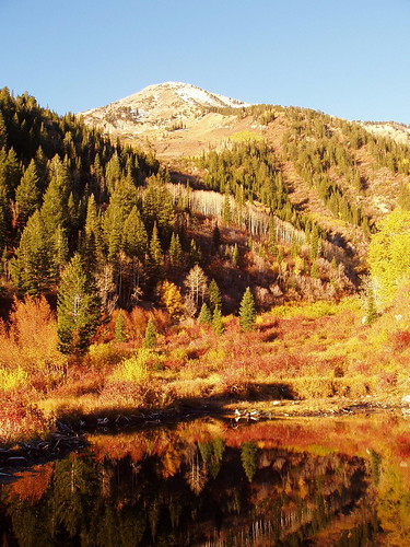
The trail begins just past the entrance to the campground, and the trailhead is well marked. For the first little while, we only gained moderate elevation, as we meandered through golden aspens and watched dawn creep down the mountain. Soon, we were in sunlight, and began shedding layers as the temperature rapidly increased. As the trail got higher, the trees got thinner, and our views opened up to stunnning vistas, especially of Mount Timpanogos to the south.
We spent a while following switchbacks on the north side of the canyon above Deer Creek. The trail eventually levels out and goes through a rock field or two that reminded Bruce and I a lot of the terrain on Mount Whitney a few months earlier. After a couple of ups and downs, we arrived at the Deer Creek divide, where the Dry Creek trail from the west meets the Deer Creek trail from the east. The junction is in the middle of a nice little meadow, and is well marked. We took a right to continue to the summit.
From there we followed the trail as it started to take a more direct route to the summit. From the saddle where the Dry Creek trail come up, we actually gained a couple hundred feet and then lost them descending to a second saddle at the base of the final ridge climb. The views of the rest of the Lone Peak Wilderness and other peaks were incredible. Additionally, we had a pretty good view of Utah Valley to our west, and were high enough to catch glimpses of the Salt Lake Valley.
The last pitch was 1,700 feet of ridge, and snow covered ridge at that. There were places where the snow had melted, but most of the ridge had at least lingering snow from any early storm a week earlier. We were fortunate to be following the tracks of a couple of people who were ahead of us on the trail, and we were grateful as a real trail was difficult to spot. I almost pulled out the gaiters a time or two, but instead settled for some snow in my boots. As far as ridges go, this one was fairly well behaved, without very many ups and downs, just a constant grade to the summit, which was visible the whole time.
We finally got to the summit around noon, and enjoyed the great views which that vantage point offered. The temperature at the summit was substantially lower than the climb up, and the wind was blowing pretty good as well, which made for a chilling summit experience. After signing the summit register, taking some pictures and congratulating each other on a successful summit, we began the walk back down to the trailhead.
Because I had some pressing time commitments that afternoon, we didn't dally getting back to the car. We saw a few other people, but the trip down wasn't noteable, but for one exception. Right before the saddle at the base of the summit ridge, Bruce and I heard movement on the other side of a mound of dirt. As we got closer, it became apparent that we had found a pretty sizable moose, with a large rack. We were both slow on the draw, though, and only managed to get pictures of the moose as he was quite a bit farther off.
The fall foiliage was just as lovely coming down as it was up, and we made good time descending through it. We finally made it back to the car around 3pm, and enjoyed a quick ride back to Provo. Box Elder is probably the last peak of the season for me, and was great way to finish off a hiking packed summer. Time to start working on the list for next summer!


