Hoosier Hill Trip Report
Elliot Road, 03/31/06
When most people think if Indiana, they think of basketball, autoracing and corn. The state is mostly flat, and driving the interstate across it reveals miles and miles of corn fields. But every state has to have at least one point to call the highest, and in Indiana this is the aptly named Hoosier Hill. In late March 2006, I was visiting the University of Illinois in Urbana-Champaign. My schedule was such that I was able to leave in the early afternoon on the last day and drive out to the highpoint.
The day has been windy as a frontal system was moving through the Midwest. The skies were clear, though, as I began my drive. I managed to make good time on the highway and was able to reach the Richmond, Indiana exit in about 3 hours. By the time I got there, it was late afternoon and there were patchy clouds in the sky, but the temperature was still in the 60s. I exited the interstate and began wending my way north on SR 223 through the little towns of Middleboro and Whitewater.
The road is quite hilly and at times I felt as though I were on a rollercoaster. I noticed a couple of hills that had divets in the road on the other side where it looked as though somebody had gotten some air and then landed hard. After about 10 miles, I came to the town of Bethel and proceeded a few hundred yards past that to County Line Road which separates Wayne and Randolph counties. At this point, there were signs pointing out the highpoint which were pretty easy to follow. I turned west on County Line Road, drove about a mile and then went south on Elliot road (again, following the signs) and saw the highpoint area not far away.
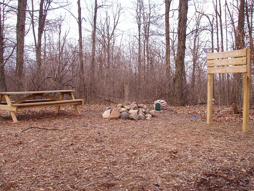
The weather was still cloudy, but occasionally the sun would break through. As I got out of my car, I found that the wind was still very strong and the clouds were moving along at a pretty good clip. From my car, I proceeded down a little gravel lane and then turned into the highpoint area. It turns out the highpoint is on privately owned land, but the landowners are friendly to visitors. Apparently, the area used to be fairly run down, but one of the local Boy Scouts took it upon himself to improve it for his Eagle project. Now, there is a sign and a couple of benches, as well as a log book.
I tried to sign the log, but it was wet from the rain the previous night. Instead, I spent a few minutes at the summit taking pictures and just admiring the view. Although it was early spring and the fields had not been planted yet, the view was still picturesque, with farm houses and barns dotting the landscape for some distance. I left feeling somehow satisfied and glad that I came.
My flight the next morning was an early one out of Chicago-Midway and I had a room reserved a ways out of Chicago, so I began the long drive back. I had been tempted to continue on to Campbell Hill in Ohio, but the lateness of the hour and the earliness of my flight convinced me otherwise. The only real bit of excitement on the return drive came as I was going around Indianapolis as I passed through massive and rapidly moving line of thunderstorms. I was only in it for a few minutes, but I was treated to a spectacular display of lightning for most of the evening. I later heard that the same storm spawned a few tornadoes, but luckily they were far from me.
One of the reasons I enjoy highpointing is just the fact that I can see new places, ones which not very many people visit. Hoosier Hill is one such place. Although having the company of my family would have improved the trip considerably, it was enjoyable, and a nice afternoon break from the grind of daily life.

