Charles Mound Trip Report
Wuebbels Lane, 07/05/14
In spite of its rather modest height, Charles Mound, the highpoint of Illinois, is a bit tricky to summit. This is mostly due to the fact that it is on private property, and (as of our ascent) the owners only allow access during four weekends of the year, the first weekends of June, July, August and September. During our 2014 Summer Road Trip, a cross-country trip planned from our home in Pittsburgh back to Utah, our route would take us relatively close to Charles Mound on one of the access dates. Although the timing wasn't intentional, I couldn't pass up an opportunity to notch another highpoint, particularly given the access limitations.
We probably managed to pick the best day of the summer to attempt the hike up Charles Mound. We spent the day before in Nauvoo, Illinois, visiting various Mormon history sites. During a time that is usually hot and humid, we had mid-70s and clear-but-dry weather. On waking Saturday morning, I noticed that a large storm system was coming across Iowa toward northwestern Illinois, but with luck, we'd miss it during our visit to this highpoint.
We were lucky. The 4-hour drive from Nauvoo to the town of Scales Mound was largely uneventful, save for the proximity of the flooding Mississippi River. It was rising to the point of flooding nearby yards and homes, and probably would have covered the road given another couple of feet. It was interesting to behold, but made me glad flooding isn't a problem I face regularly.
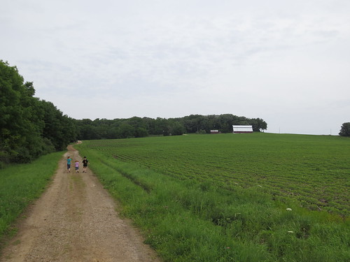
From Scales Mound, we followed Charles Mound Road from the north end of town about 1.5 miles to the front gate of the property that Charles Mound sits on, which is owned by the Wuebbels family. The gate is marked by the address "688", but it wasn't hard to find with the several cars parked in front of it. It would appear that given the limited access to the site, the days that are open are popular with highpointers.
We parked the car and began our hike. The route isn't hard to find or follow, as it follows the owners' lane right to the summit. The lane makes several curves and gains nearly 250 feet from the road, but is never hard to follow. It started almost covered by woods, and then opened into a soybean field before finishing in another wood at the top of Charles Mound. All told, it is about a mile from the road to the highpoint.
In many ways, this was a trial hike for the other ones that would come later in our trip (like Emerald Lake and White Butte), so we wanted to let the children do as much as they could. Our 2-year-old didn't make it very far, and spent most of the time being coaxed and carried by my wife and I. Everyone else did very well, and we managed to make it to cover the mile up the hill in about 40 minutes. Although it didn't rain, the storms moving across Iowa were kicking up a bit of wind.

The entire day, we met a steady stream of hikers on the trip, with folks taking advantage of the good weather and the access dates. There was a certain degree of camaraderie, as we asked other visitors how many highpoints they had done, and where they were headed next. It may be kind of a kooky hobby at this point, but it's nice to have company.
Our trip down took almost as long as the way up, partly because we kept stopping to sample the wild blackberries that grew along the side of the path. Once we got back to the car, we loaded everybody up and made our way to Galena for lunch, before heading to the Field of Dreams movie set and to points west for further adventures. Another highpoint was in the bag.