Santaquin Peak Trip Report
Mud Hollow, 07/16/05
What a difference a few weeks makes. After being stormed off the mountain in mid-June, Heather and I again made an attempt on Santaquin Peak three weeks later. The area had gone through a substantial warm spell, so we figured that the snow we encountered the first time would also be less. There wasn't any rain in the forecast, and I was finishing up my preparations for Mount Whitney, so we decided to make the climb.
We had gotten up earlier this time, and also had an easier time getting to the Nebo Loop. The exit off the freeway is 250, not 254 like the literature I had read suggested, although it appeared the freeway exits had recently been renumbered. As we went up the Loop, we learned that the area is summer range for cattle, and we were even delay a few minutes by a herd as as they were being moved up the road.
We made it to the trailhead and were on our way by 7:30. We had done our research, and learned that the quickest way up the mountain wasn't the route we used last time, but instead the prefered way was to take a left at the coral and follow the Loafer Mountain trail up Mud Hollow. After going left at the coral, the trail descends to the Bennie Creek cutoff, and then makes its way back up to the side of the mountain, where it gradually gains elevation until it hits a ridge.
The trail continues up this ridge for a while until it hits a saddle. One guidebook that I have indicates this saddle as a good camp site, and it was evident that it had been used as such. By this point we had reached 9500 ft., only 1100 ft. below the summit. We also got our first glimpse of Santaquin Peak, which looked close and attainable. However, looks can be deceiving, as we weren't even half way to the summit.
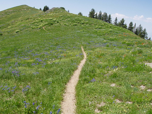
Once at this saddle, the trail traverses the main Loafer Mountain ridge for a bit. There are several undulating stretches which, while not steep, can get a little tiresome on the descent. We followed the ridge around to the point beneath Loafer Mountain where we turned around the previous time. We were amazed at how great the landscape had become in just those few short weeks. The snow was almost melted and the hill had turned into a sea of wildflowers and grass. The only drawback were the flies, which seemed to be ubiquitous whenever we stopped, even for a moment.
Instead of continuing along the ridge up to Loafer Mountain, the trail turns north and goes around the side. The summit was visible, and I thought it would only be a short distance. Again, the distance was deceiving, because a drainage lies between that portion of the trail and summit, requiring quite a bit of a walk to make it all the way across to the summit. The trail remained level, and we continued to follow it to the notch right beneath the summit, crossing an occasional remnant of snow. Looking back, we would have been hard pressed to follow this route with all the snow that was on the mountain during our first attempt.
From the saddle beneath Santaquin, the trail again becomes very steep, but this time, we were very close to the summit. We met our first fellow hiking of the day as he passed us on the final pitch to the summit. We too eventually made it to the summit, and were greeted with a grand view of Utah Valley and the surrounding mountains. The air was a little hazy, but we were still able to make out the major peaks: Mount Nebo, Provo Peak, Spanish Fork Peak, and Mount Timpanogos. Even the Stansbury Range, home of Deseret Peak, was visible off in the distance.
Also on the summit was a troop of Boy Scouts, who were participating in Operation On-Target, an annual event in which different troops climb various mountain summits and then signal each other with mirrors. We had seen Provo Peak flashing earlier in the morning, and figured somebody was on it with a mirror. It wasn't until we reached the summit, however, that we learned what the mirrors were for. While on the summit, we ate lunch and just enjoyed the view.
The descent was about as uneventful as descents can be. The day had gotten substantially warmer, and although comfortable at 10,000+ ft., was a little bit toasty lower down. The trail is fairly exposed for most of the way, and as a result, Heather and I both ended up with a bit of sun. The undulations also came back to haunt us as we were going down. After 10 miles of hiking, a couple-hundred-foot ascent can look mighty tall. We did eventually make it safely back the car, 7½ hours later. Santaquin Peak was a good hike, scenic and enjoyable, and we are both glad that we made it up the second time around.

