Santaquin Peak Trip Report
Deer Hollow, 06/25/05
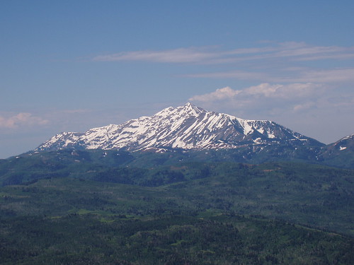
Santaquin Peak, although two feet lower than its sister, Loafer Mountain, is very prominent from Utah Valley. Both can be climbed easily in the same hike, but because of its location to the north, Santaquin offers great views of the valley. Heather and I set out to tackle it on a great Saturday morning. Although I was gearing up for Whitney and she hadn't been hiking in a while, it turned out to be a challenging experience for both of us.

It had been a late night the night before, and as a result, I was a bit late in getting up that morning. Also the directions we had for getting to the Nebo Loop were a bit off, so it took us longer to get there than we planned. We were able to find the trailhead without any difficulty, and start hiking around 8 am, later than we planned, but still plenty cool for a Saturday in June. Neither of us had been on the trail before, but I had read other trip reports on the web, and felt confident in our ability to get up the mountain. The sky was clear as we began our climb.
Shorty after the trailhead, we came to a fork in the trail, and veered left. A little ways farther, we went through a gate in a fence, and then came to another fork. Although not signed, I later learned that the left fork goes up the Mud Hollow route, while the right fork crosses over to the Deer Hollow route, which is longer and has more elevation drop and subsequent gain. We took the right fork, and thereby made the hike a little more difficult than it otherwise could or should have been. From the fork, we went through another gate (actually, we went over the gate because we couldn't get it open), and then followed the trail over to Deer Hollow.
The Deer Hollow Route crosses over to the next drainage south of Mud Hollow, and we followed the trail as it dipped down into that draw. We probably lost a couple of hundred feet in crossing over, and the real climb started as we began to make our way up Deer Hollow. The weather was still nice, and as we hiked up a rather steep trail through aspen groves with the occasional break in the trees. The only other people we saw on the hike were four men on horseback descending the trail as we went up. We finally topped out of the draw at a nice little meadow and could see for miles to the south in the direction of the Sanpete Valley.
The trail continued upward, following a fairly round ridge for some distance until we reached a saddle beneath the summit of Loafer. This saddle was on the south side, and we had excellent views of the sheer side of Loafer Mountain. The trail we were on continued over the east over the saddle, but it was covered in snow and cornices. Instead, we followed another trail which cut back around toward the west, and eventually met up with the trail coming up from Mud Hollow at yet another saddle, where we finally got our first glimpse of Santaquin Peak.
It was at this point that we started to notice the menacing clouds gathering over Mount Nebo to the southwest. What had been clear skies earlier in the day had turned into grey clouds, which were rapidly surrounding our position. We were beginning to make our way up the ridge toward Loafer, but the trail got lost under snow, and the going was a bit steeper than we were prepared for. Plus, we hadn't expected snow, so we weren't prepared for with the normal snow gear. To make matters more interesting, we saw a couple of strokes of lightening at one point as we were resting and looking back toward Mount Nebo. That was the turning point, and we decided that it would be prudent to head back down and save Santaquin for another day.
The decent was relatively uneventful. One of the hardest parts of aborting a climb is the "what ifs" that often pop into my mind on the way down. I wonder why I quit, and if I could have done it. These were satisfied this time as we looked back and saw dark clouds on the ridge where we would have been. We did have the occasional spot of sun, but for the most part, the weather was threatening. We made it back to the car early in the afternoon, and enjoyed a drive on the scenic Nebo Loop. Overall, it was a good hike, not too challenging, but still a little. We'll be sure to get back up Santaquin before the summer is out.
