Deseret Peak Trip Report
South Willow Creek, 06/26/04
Ever since hearing about Deseret Peak a few months ago, I've been wanting to climb it. By all accounts, the hike was reported to be pretty, but not that difficult. Also, because of it's location in the Stansbury Mountains, it is far removed from most of the typical hikes in Utah's Wasatch Mountains, and thus a lot less traveled than some of the more popular hikes.
Because the trailhead is 2 hours away from my apartment in Provo, I decided to get up early to get climbing early. The weather forecast the night before had predicted scattered afternoon thunderstorms, and I had no intention of being caught on the highest point in the Stansbury range during a thunderstorm. My plans went awry, however and I didn't end up leaving until 9am. I took I-15 north into Salt Lake, and then I-80 west toward Grantsville, getting off on Exit 88, and traveling into town. It took me a while to find it, but I finally exited the town going south on South Willow Road, which is on the west side of town.
After a few more detours, I found the sign pointing to the Willow Canyon and Loop Campgrounds. The trailhead is eight miles down the Willow Canyon road, half of which are on dirt. Having a four-wheel drive vehicle would have been nice, but my little passenger car managed just fine. The same cannot be said of the large numbers of huge crickets which were sunning themselves on the road as I rumbled past.
The trailhead is well marked and the trail itself is not hard to find. The trail to Deseret Peak makes a sort of loop. Most people prefer to both ascend and descend along the Mill Fork trail, as it is both shorter, and often clear of snow earlier in the season. However, the reports that I had read previous to going indicated that the ridge trail makes for a nice descent. I decided that time and weather permitting, I would take the Mill Fork trail up and then descend using the longer ridge trail.
I went about three-quarters of a mile from the trailhead before I encountered the first fork. The sign at the fork points toward the left as the way to go to Deseret Peak. This is the Mill Fork trail. I followed this trail without incident for about a mile and a half. As the altitude started getting higher and the trail steeper, I really started to struggle, and found myself stopping often the catch my breath. The switchbacks leading to the ridge are fairly steep, but still navigable. To make matters even more interesting, I heard thunder a couple of times, but the clouds seemed to be farther to the south than I was. Since the trail turned back around to the north, I really didn't think much of it.
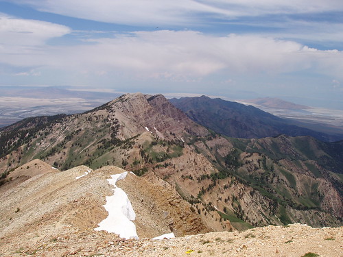
A sign at the ridge points the direction to various other trails. To go to Deseret Peak, I followed the rightmost trail as it climbed what I thought was the summit. In reality, it turned out that the trail only skirted this 10,647 ft. peak on it's way to the true summit at 11,031 ft. The climb was still steep but doable. The view from the summit is incredible, I could see land in every direction stretching out for miles. It was a pretty awesome sight, and well worth the huffing and puffing that it took to get there.
My stay at the top was short lived, however, as the thunder sounded occasionally from the clouds to the south, and another storm cloud appeared heading in my direction. After consulting the map, I decided to take the ridge trail, as it would take me farther north, and hopefully out of the way of the storm. My only concern was that the trail would undulate, but it didn't appear that way from the map, and I was mainly concerned with getting down off of the summit. The ridge trail was also slightly less exposed, initially, so it posed less threat of a lightening strike.
The ridge trail turned out to be quite well maintained as well, although I could tell that it was far less used than the Mill Fork trail. I had to cross a few snow fields on my descent, to the first saddle, and with all the thunder, the storm only managed to spit on me. At the first saddle, there is a sign which points north indicating the trail. I would guess, though, that a number of people try to cut down the saddle and drop into Dry Lake Fork. Although this may be quicker, I would suggest following the trail to the north, as it offers some great views, and is probably a bit easier.
After skirting another peak, I came to the saddle above Pockets Fork. The trail disappeared into a snow field, and reappeared about a hundred feet below. I wasn't equipped to glissade down the snow field, and not willing to try and cross it, I just picked my way down the side of the mountain until I intercepted the trail. The trail disappeared into a few more snow fields as I descended, and I finally gave up following it for a while, and picked my way down a combination of snow and scree. After the scree gave out, I bushwhacked my way back to the trail. I suspect that the snow would be gone by mid-July, making the way down Pockets Fork a bit easier.
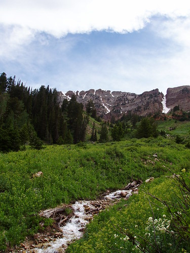
The trail from Pockets Fork intercepts the trail from Mining Fork, and then drops down into Dry Lake Fork. The trail coming into Dry Lake Fork offered some of the best scenery of the entire trip, with a great view of the cliffs that make up the eastern side of the Deseret Peak ridge. I imagine the orange cliffs look spectacular in the morning when the sun is just rising; I was only able to catch them as the sun was behind, and the sky a bit cloudy.
After crossing a couple streams, the descent back to the Mill Fork turnoff is pretty easy, as the trees start to come back, and the vegetation grows more dense. I managed to do the accent in about two hours, while the slightly longer descent took just over two hours. A couple of hikers I met on the trail mentioned that one of the guidebooks rated this hike at "moderately difficult", and I wouldn't doubt it, but it is something which even a casual hiker can do.
Instead of taking the interstate back to Provo, I decided to take the back roads through the towns of Rush Valley, Mercur and Lehi. The landscape was relatively barren, of both people and vegitation; but still pretty, in a desert sort of way. The desert valleys with the partly cloudy ceiling were quite picturesque. The travel was easy going, and I arrived back home around 6pm. I was tired and my knee was bothering me a little, but the hike up in the mountains was definately worth it. I would recommend Deseret Peak to anybody, as one of the better kept hiking secrets in Utah.


