White Butte Trip Report
Farmhouse Trail, 07/22/14
The return journey on our 2014 Summer Road Trip took my family and I through North Dakota. We decided to spend a night at Theodore Roosevelt National Park, which was more enjoyable than we expected. So enjoyable, in fact, that we spent the entire morning driving around the park, before we left to begin our hike of White Butte, the highest point in North Dakota. Fortunately, the weather was excellent, and even though we were facing a midday start, we were comfortable in shorts and t-shirts.
White Butte is the highest point in North Dakota, and while the summit is itself part of the Little Missouri National Grassland, the access to the summit is over private property. Getting to the trailhead wasn't difficult, as we followed the direction on SummitPost and the Holmes book (even Google Maps was able to navigate there). Deciding where to park and actually start the hike took more effort.
We had done some research prior to coming, and most instructions said to park as the local farmhouse to get permission to cross the property, before driving further to an old abandoned farmhouse to begin the hike. We were confused, as the main farmhouse appeared to be itself abandoned, and any road to the older farmhouse had long transformed into a tractor-only trail. The hay had just been cut, but after seriously considering driving my minivan across a strange farm field, I wisely took my wife’s counsel, and we retreated to a mailbox which marks the start of the trail.
The instructions are the mailbox were faded, but from our research we decided it would be appropriate to put a few dollars in it as a donation for crossing the private property. (The box was locked with a rather new padlock, so I figured somebody would come along to collect our payment.) By this time, it was close to 1:15 in the afternoon, so we got the children ready to go and set out. Since the hay had been cut, it was much easier to walk along the margins of the field, rather than through the tall grass that bounded the tractor trail to the old farmhouse. The route was completely open, save for the occasional large bush, so our goal was in sight the entire way.
I was carrying our 2-year-old, but early on I could tell it was going to be slow going for the 3-year-old and my pregnant wife. After only a couple hundred yards, we decided that the younger kids would say with my wife at the car, while our two older children (5 and 7 years old) would continue with me. We swapped gear, and got ready to proceed with our plan. We had also heard about the possibility of snakes on the butte, so we made sure to keep a close watch for them. In spite of all the warnings about rattlesnakes, we didn’t see any during the entire hike.
We walked along the old tractor trail, eventually passing the older farmhouse and going through a gate in the fence. The grew larger and larger as we approached its base, and the nature of the soil transitioned from dark loam to a white dirt that makes up the butte. Once at its base, we had two choices: to follow the fence line straight up the butte; or go to the right and follow a dry streambed that looked like it might be a trail. Since the latter looked easier, that’s what we chose, and we shortly came upon a proper trail to take us to up the butte.
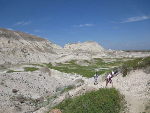
There were a couple of steep pitches, but it ultimately wasn’t that challenging of a climb: the kids did just fine. The trail wound its way up to a level field and passed around a clump of small trees. From there, it was a short way up to the main ridge of the butte, where we got a great view of the surrounding areas. It felt a lot like the scenery we had seen earlier in the day at Theodore Roosevelt National Park. A few minutes of following the trail along the ridge, and we were at the top of North Dakota.
The day was beautiful and despite it’s relatively low prominence over the surrounding terrain, the views were amazing. All around were the grasslands, farms and buttes of southwestern North Dakota. We could also look back over our entire route, and see the blue speck of the minivan as the trailhead. Jonathan, Hannah and I ate some snacks, took some pictures and hung out for a bit before Hannah decided there were too many bugs and we should start our trek back. Just before leaving, I noticed another car parked near ours, and a group of three making their way up the trail.
Our hike down was uneventful, though the distance from the old farmhouse to the car seemed to take forever. As we got closer, we saw Heather and the younger children forming a welcoming party for our return. Even though we had been gone for more than two hours, they reported a good time together, cleaning the car, reading stories and playing in the dirt. I’m glad that even though they didn’t get to come on the hike, they still enjoyed the time.
It took a while to get back to civilization, but after lunch and shopping in Dickinson, it was almost 4:30. With sadness, we left this lovely part of North Dakota, and drove another four hours to rendezvous with a friend in Moorhead, Minnesota for the night. While we may not hike White Butte again, I can see us returning to the area for more hiking and camping in the surrounding grasslands. It was a good summit of my 19th highpoint, and a great day in North Dakota.

