Cascade Mountain Trip Report
Dry Fork, 06/18/05
Another week, another attempt on Cascade. This time I went with Bruce, and we decided to try the more tried and tested Dry Fork route. The route is normally accessed by driving up the Squaw Peak Road to a point just above the Rock Canyon Campground. The trail then runs east up to the ridge. From there, the route traverses the ridge north, then west, and finally north again to the summit. The route has been noted as being difficult, and to make things even more exciting, we started at the Rock Canyon trailhead from the valley floor, because we were unsure about the passability of the Squaw Peak Road.
The morning was beautiful, and the weather for the day was forecast to be nice, if just a little windy. We got up early, and made good time going up Rock Canyon. We reached the road, and saw the remnants of an avalanche from earlier in the season. It appeared that this side of Cascade was not immune to the avalanche conditions that plagued the eastern aspects. However, the trail was not blocked by this avalanche, and we were able to continue on our way.

Shortly after crossing the road, however, we did run upon the avalanche, which gave us a moment's pause. Bruce and I toyed with the idea of simply bushwhacking up one of the many draws that goes from Dry Fork up to the ridge, but ended up taking the more prudent course and continuing to follow the trail up the valley. The only other person we saw on the mountain that day, Jeff, helped us locate the trail on the other side of the avalanche, and we continued following it up Dry Fork.
Eventually, though the trail did find its way under snow. We had planned on following it up to the ridge, but instead we settled for bushwhacking up the terraces on the side of the ridge. Back in the 1930's, the CCC constructed huge terraces along the steep mountainsides in the Wasatch. Although using them probably cut a mile or two off of the route, the terraces were steep, and our ascension ritual involved climbing to one, catching our breathes, planning our next route and then repeating. The terraces were useful when walking across the mountain, but sure are unpleasant to climb.
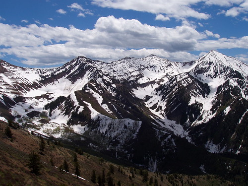
Once to the top of the ridge, we got our first views of the summit and the terrain to the east. There was still a large amount of snow on the eastern side of the mountain, with cornices on the ridge. The side we were on was clear, but having the cornices severely limited our options when trying to navigate the ridge. To make matters worse, the wind had picked up, and was blowing at 30-40 miles per hour, which made keeping our balance hard at times. The ridge wasn't smooth either, and although we were sometimes able to find a trail, we were constantly going up and down.

After a couple hours of traversing, we were still 1.7 miles from the summit. We were coming close to our turnaround time, and the ridge was looking more and more treacherous. In addition, the wind wasn't letting up, and we were concerned about our ability to continue. The elevation was 10,150 ft., 750 ft. vertical short of the summit, but still a long walk away. We decided to eat some lunch, take some pictures, and head back down. Instead of going back the way we came, we decided to simply head down the draw that we contemplated going up earlier in the day.
Descending the draw turned out to be a little bit more a task than we planned. We had to descend about 3000 feet over some very steep scree and talus. There was the occasional snowfield that allowed for a standing glissade, but overall it was slow going. When we finally made it back down to the trail, it was only a short way to the Squaw Peak Road, and then the final hike down to the Rock Canyon trailhead.
Even though it was a hard hike, and we didn't summit, I really enjoyed it. We were able to get a good workout in preparation for Whitney in July, and we were able to see some spectacular scenery. I would imagine that the Dry Fork route is more doable during the summer months when the mountain is clear of snow, but probably still difficult. Next time up this mountain, I think I'm going to try one of the routes on the west face, a bit steep, but probably our best shot up the mountain.